Entry Points:

About Inyokern
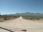
Inyokern lies in the wide open space of Indian Wells Valley, with the imposing slopes of the Sierra Nevadas rising to the west. The pointed tip of Owens Peak, at 8,453 feet in elevation, is a prominent landmark visible throughout the town. Creosote is the main desert vegetation to be seen covering miles of the surrounding valley. When winter rains are plentiful, thousands of flowering plants spring up and live for just a short time before the extreme summer heat.
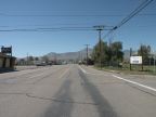
The Southern Pacific Railroad used to pass through Inyokern and brought about its settlement, but today the railroad grade is abandoned. The earlier route of U.S. Highway 395 passes through Inyokern, and the current route bypasses it just to the east. State Highway 178 crosses through east to west, leading to Ridgecrest on the east, and into the Sierras on the west.
The population of Inyokern in 2000 was 984. It is not incorporated.