Entry Points:

About Santa Cruz County
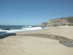
Santa Cruz County covers 607 square miles along the Pacific coast of California. The crest of the Santa Cruz Mountains, rising above 3,000 feet in elevation, form the inland boundary of the county on the northeast side. The Santa Cruz River (which is dry) forms part of the southern boundary on the east side. The Monterey Bay lies to the south and the Pacific Ocean to the west, meeting the land on many beautiful cliff-lined beaches. The mountains are covered in beautiful forests, while grasslands cover the lower hills, broken by patches of trees and brush. Numerous canyon and gulches cut through the hills towards the sea.
Santa Cruz County was one of the original counties created in 1850 when California became a state. It is named after the Mission Santa Cruz established here in 1791. Santa Cruz is Spanish for "holy cross," referring to the cross upon which Jesus Christ was crucified. At the time of its creation, the county was named Branciforte, after a Spanish pueblo built here in 1797, but this name was changed after a couple months. The city of Santa Cruz is the county seat.
California Highway 1 follows the coast through the county, being a freeway southeast of Santa Cruz, and a highway to the northwest of there. California Highway 17, a freeway, passes over the Santa Cruz Mountains to San Jose to the north. Many cities and towns line the coast and are nestled away in the hills and mountains. As of the year 2000, the population was 255,602.