Entry Points:

About Mariposa
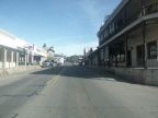
At 2,000 feet in the foothills of the Sierra Nevadas, Mariposa is nestled in a canyon surrounded by steep hills covered with forests of small trees and brush. A grid of narrow streets comprises the core of the town, with a few meandering roads leading into the surrounding hills.
Mariposa was established by explorer John C. Fremont during his efforts to settle California and establish it as a U.S. territory. He established the city to mine for gold on the land grant which he obtained from the then Mexican governor of California. The city is named after Mariposa Creek, which flows through the town, which was named by the spanish for the swarms of butterflies they found here.
Mariposa is a gateway to Yosemite National Park. California Highway 140, passing through mariposa, leads to the front entrance to Yosemite Valley. Tourism is the main economic force in the county. California Highway 49 also passes through Mariposa.