Entry Points:

About Inyo County
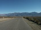
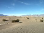
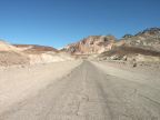
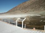
The Sierra Nevada Mountains form the western boundary of Inyo County, with Mt. Whitney, the tallest point in the continental United States, located at the midpoint along this boundary. These mountains cast a "rain shadow" effect on all of Inyo County, resulting in dry, hot desert conditions. Death Valley National Park covers about half the area of the county. Creosote and saltbush stretch for miles over valleys and slopes. Salt flats and hardpans remain at the bottom of valleys where lakes have dried up.
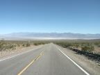
U.S. Highway 395 traverses Inyo County at the base of the Sierra Nevadas, heading north and south near the western border of the county. Creeks from the mountains supply water for towns which lie along this highway, including Bishop, Independence and Lone Pine. This is where most of the population of the county lives.
Mountain ranges running north to south divide the county into several valleys, Owens Valley, Saline Valley, Panamint Valley and Death Valley. The mountain ranges include the Cosco Range, the Inyo Mountains, The Argus Range, the Panamint Range and the Amargosa Range.
Inyo County covers 10,203 square miles and is home to 17,945 people (as of the year 2000.) It is the tenth largest county in land area. Mount Whitney is the highest point at 14,505 feet. The lowest point in the western hemisphere is also in Inyo County at Badwater Basin, 282 feet below sea level.